Guided Torres del Paine W
Hike the famous Torres del Paine W trek in Chile on a guided group tour.
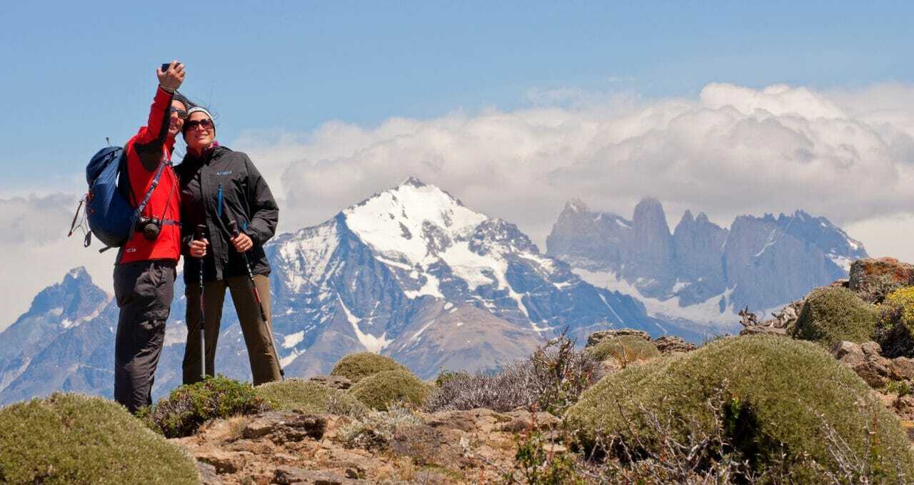
Don’t miss any part of Torres del Paine National Park’s W hike — you’ll visit the Towers of Paine, the French Valley, Lake Nordenskjöld, and Grey Glacier.
Discover the wide-open spaces of Torres del Paine National Park on this W trek, and let us do the logistics.
Guided Trek: Regular departures hiking with a group and local guide (max. 8 people per group), with all logistic covered, camping or refugios, and optional upgrades throughout. Bring your own sleeping bag liner and towel.
Prefer to go at your own pace? Check our self-guided Paine W treks: We’ll do the logistics, reserving the buses, entrance fees, ferries, and meals, so you can concentrate on hiking.
Logistics Organised For You
For both, choose to stay in fully equipped campsites or mountain refuges/hostels where everything is ready for you upon arrival. There are hot showers, warm meals, and campsite chat from fellow trekkers to enjoy. Read all about how it works with Kat’s insightful Paine W trek review.
You carry your own belongings in your backpack for both options; we suggest a maximum of 15kg.
More on trekking the guided Torres del Paine W trek, Patagonia
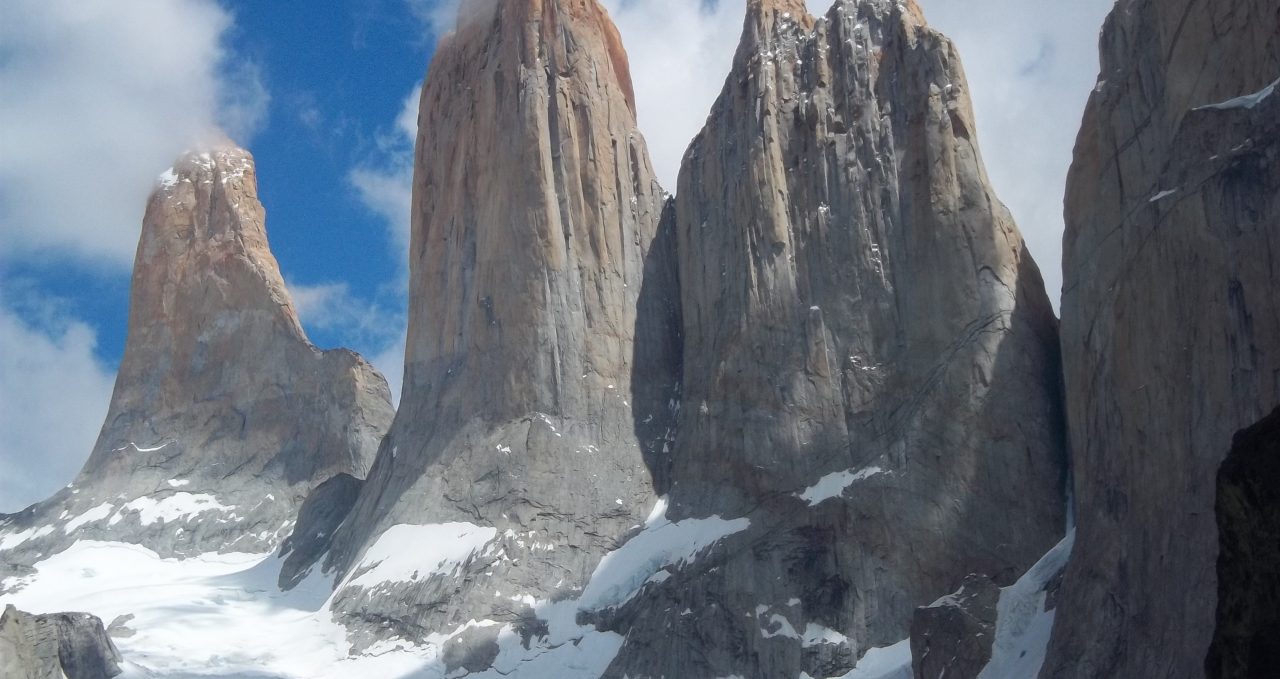
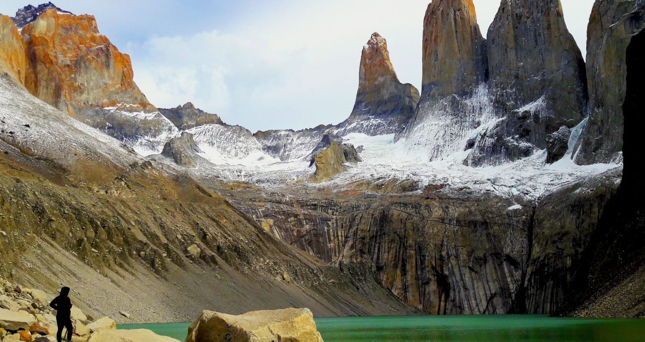
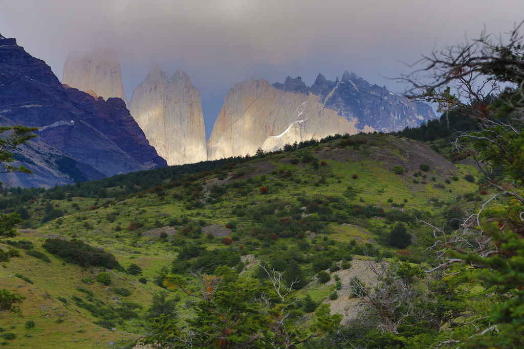
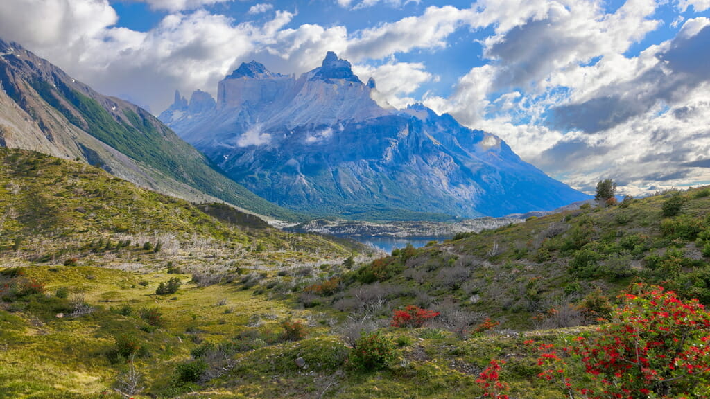
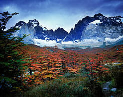
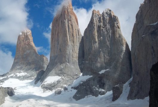
Walk to the famous granite towers that give the park its name — Torres del Paine — with fantastic views of hanging glaciers, green lakes, and mountains.
The name Paine comes from a Tehuelche Indian word meaning blue. The Torres – or Towers – are named after three spectacular granite peaks, the highest reaching 2,900m/9,514ft, that form the centrepiece of Torres del Paine.
Next, you’ll trek along the shore of the magnificent Lake Nordenskjöld, which offers stunning views over the Patagonia landscapes.
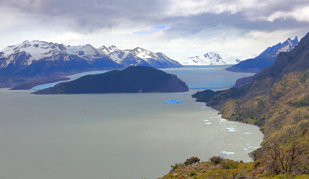
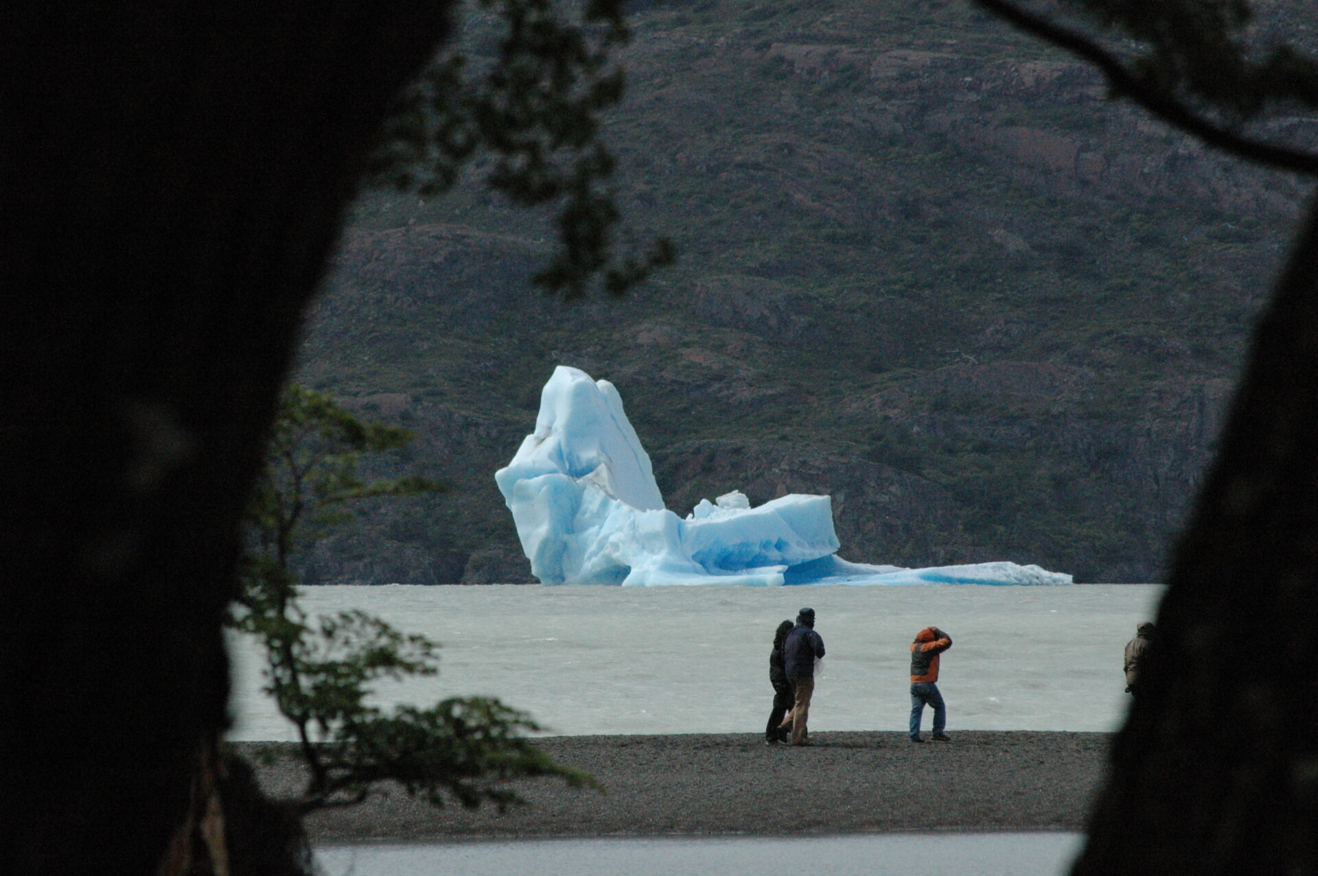
The park’s heart is the French Valley, where forests line rushing streams overlooked by the hanging glaciers of nearby mountains. Finish at Glacier Grey, whose crystal blues are made more striking when enormous chunks of its ice calve to form icebergs in the lake below.
Torres del Paine National Park Logistics
We make all the Torres del Paine W Trek reservations for you, including campsites, mountain hostels, and meals, so you can enjoy the sights. You can join a group for the hike or form your own private departure; this in the Paine W as you want it.
This Torres del Paine W trail route runs east to west, but it can also be run in the opposite direction.
Trip Highlights
Print Share Download as PDF-
Guided Torres del Paine W hike in Chilean Patagonia
-
Visit the famous Towers of Paine, French Valley, and Grey Glacier
-
All mountain hostel (refugios) and campsite reservations made for you
-
Carry only personal belongings — all meals and sleeping arrangements included
It was a FABULOUS trip – so THANK YOU! All the bookings, guides and transport that ANDEAN set up worked out very well for us and made for a great trip.
M. Gleason, Self-guided Tour
Gallery
Videos
Full Itinerary
Day 1: Transfer to park, hike to the Towers, Refugio Cerro Torres (L,D)
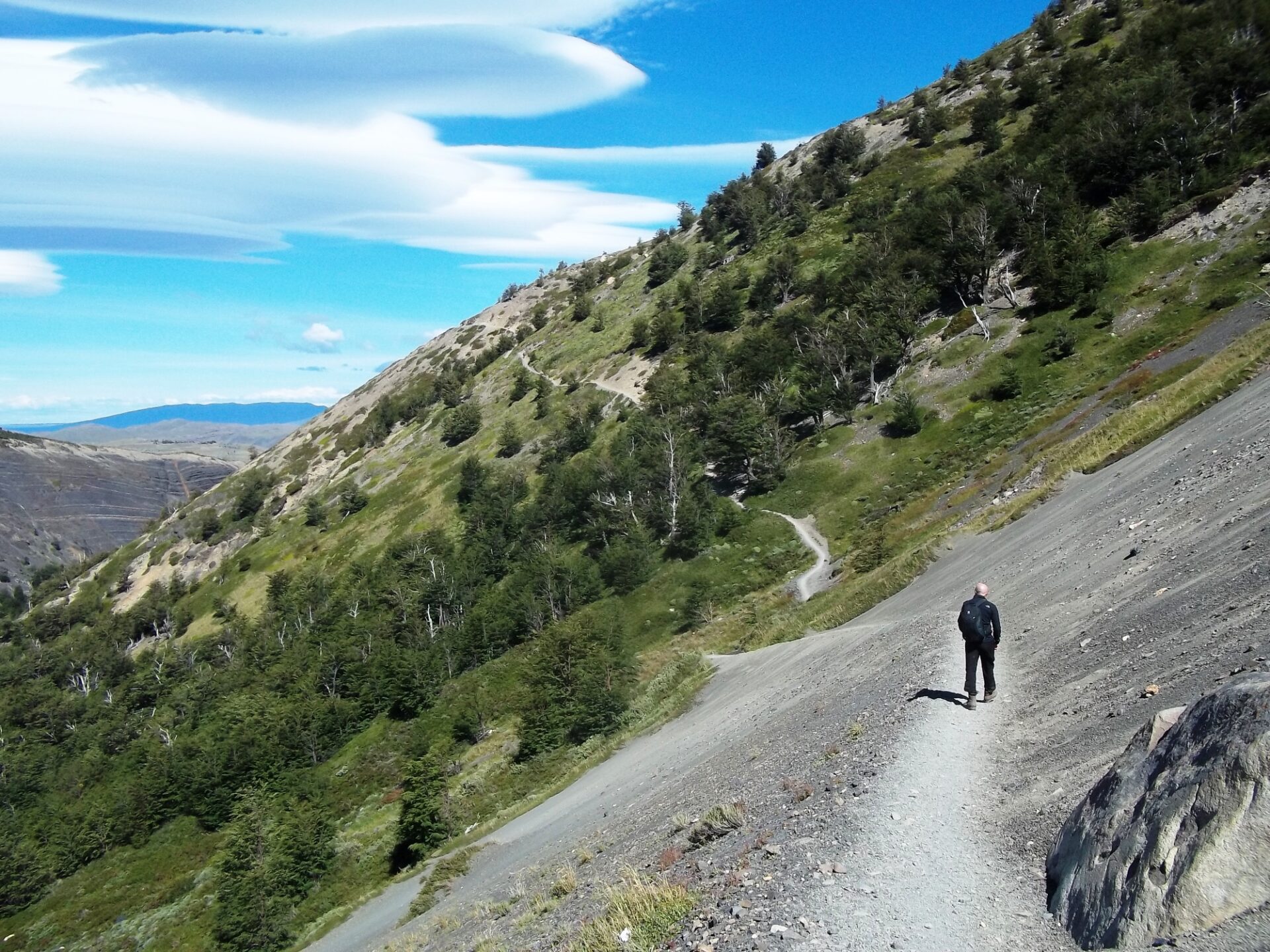
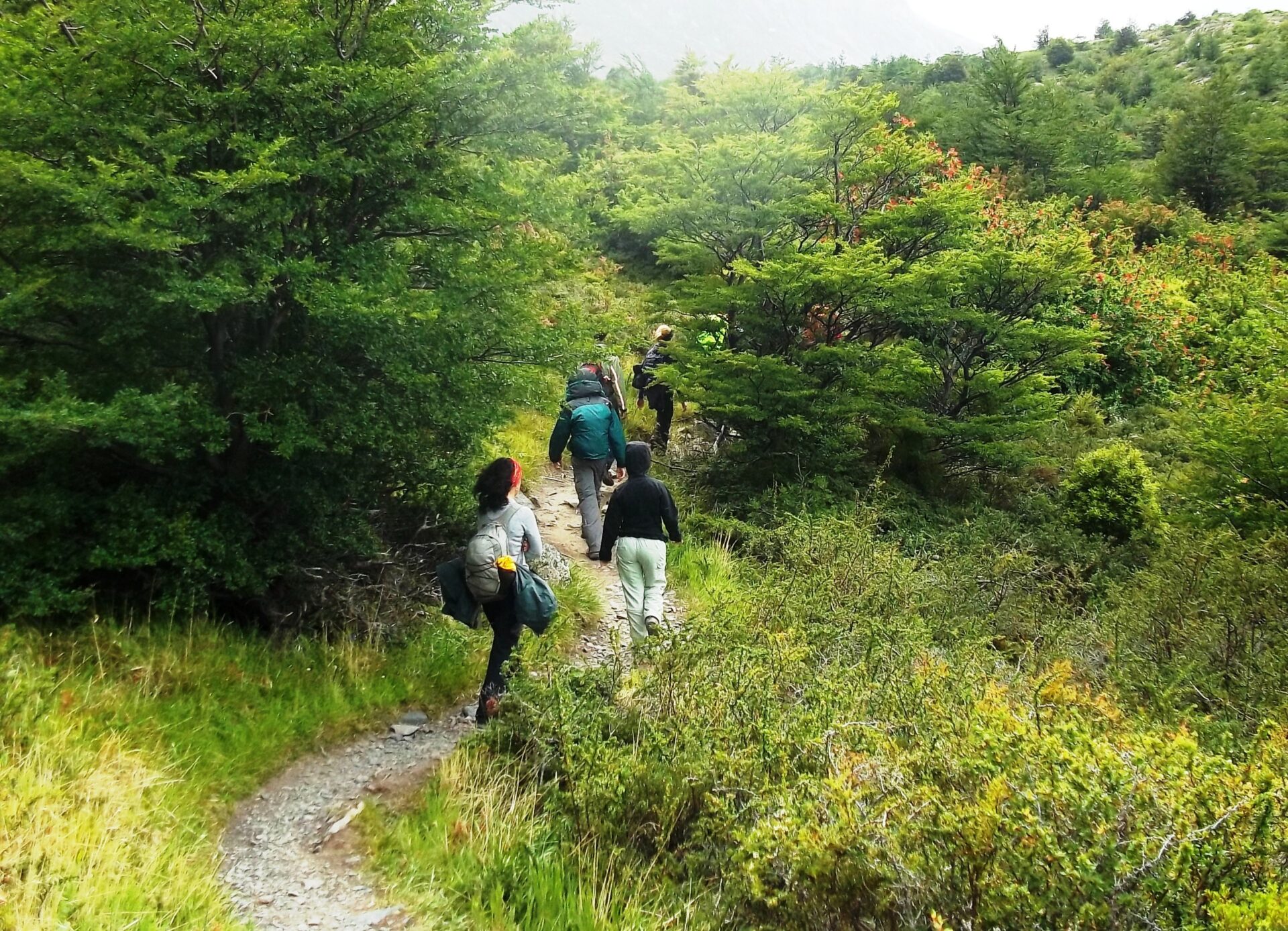
Starting from Puerto Natales at 07.00, we drive two hours to Torres del Paine National Park, passing Estancias (ranches) and flat pampas taken straight from Patagonian folklore.
Have your camera ready en route: ñandu (Patagonian ostrich), Chilean flamingos and black-necked swans are likely to be out in the pampas and lagoons. After arriving at the first Refugio you’ll have time to leave your main backpack and take just a small backpack for the day, before we begin the W Trek’s first highlight: the hike to the three Towers lookout.
The trek begins with an ascent, following the Ascencio River in the Ascencio Valley. After about an hour, we’ll stop to observe how the valley’s beauty unfolds with rich beech forests, glaciers and waterfalls.
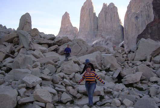
Past this lookout point, we continue uphill and through lush beech forests before ascending a gigantic terminal moraine where we’ll be rewarded by the arresting sight of the three Towers themselves. At this lookout point (900m / 2,953 ft.) above sea level, we’ll rest, take photos and have lunch.
Our descent is along the same path, taking us back to the Refugio where we’ll have dinner, stretch and rest for the evening.
Hiking: 8-10 hours, 22 km / 13.6 miles
Highest altitude: 870m/2,854ft
Difficulty: Medium/hard
Accommodation: Camping or Refugio Torre Central. Option to upgrade to a private room in Hotel Las Torres (depending on availability).
Meals included: boxed lunch, dinner
Day 2: Hike to Refugio Los Cuernos (B,L,D)
If the weather allows, our morning may be lit by the rich oranges and pinks of a Patagonian dawn. Today we’ll hike to Los Cuernos lookout, where monumental horn-shaped black twin granite peaks shoot skyward.
We’ll make our way via Inge Lagoon and may see condors and other birds of prey circling the skies while we trek below.
The well-marked trail ascends 200m from the base of Almirante Nieto Mountain (2,750m / 9,022 ft.) and crosses the Bader River to Refugio Los Cuernos or Domos Frances, today’s destination.
Hiking: 4-5 hours, 13 km / 8 miles
Altitude gained: 200m/656ft
Difficulty: Medium
Accommodation: Camping or Refugio Los Cuernos or Domo Frances, depending on availability. *Option to upgrade to a private cabin in Los Cuernos (depending on availability).
Meals included: Breakfast, boxed lunch, dinner
Day 3: French Valley, Refugio Paine Grande (B,L,D)
Today’s hike is a challenging trek to the heart of the Paine massif. The French Valley is a spectacular natural basin surrounded by peaks and hanging glaciers.
After breakfast, a winding path will take us to the French River (1-2 hour hike depending on whether our accommodation was at Los Cuernos or Domos Frances). At the entrance to the French Valley – a glacial moraine – you’ll scramble over huge boulders and catch the first sight of the hanging glacier atop the valley.
From this point, you’ll ascend for an hour through a dreamlike Japanese garden landscape before arriving at the French Valley viewpoint (the “Plateau”). Your reward is a heart-stirring bird’s eye view of granite peaks and hanging glaciers.
To one side, the French Glacier and Paine Grande (3,050m / 10,006 ft.); while to the other, La Espada, La Hoja, La Máscara and the main and north “horns” of Los Cuernos arch upwards. In the upper section of the Valley, Cerro Catedral, and Cerro Fortaleza loom like turrets above the landscape.
Take your time to have lunch at the viewpoint, surrounded by these imposing peaks and open skies.
You’ll descend via the same path until you reach the valley’s entrance, at which point you’ll continue around the south-west side of Paine Grande, Torres del Paine’s highest peak. This final leg passes through native firebush and evergreen beech forests to the shores of Pehoe Lake.
Dinner will be served at Refugio Paine Grande where we rest for our third night.
Hiking: 8-9 hours, 18 km / 11.2 miles
Highest altitude: 762m/2,500ft
Difficulty: Medium/hard
Accommodation: Camping or Refugio Paine Grande
Meals included: Breakfast, boxed lunch, dinner
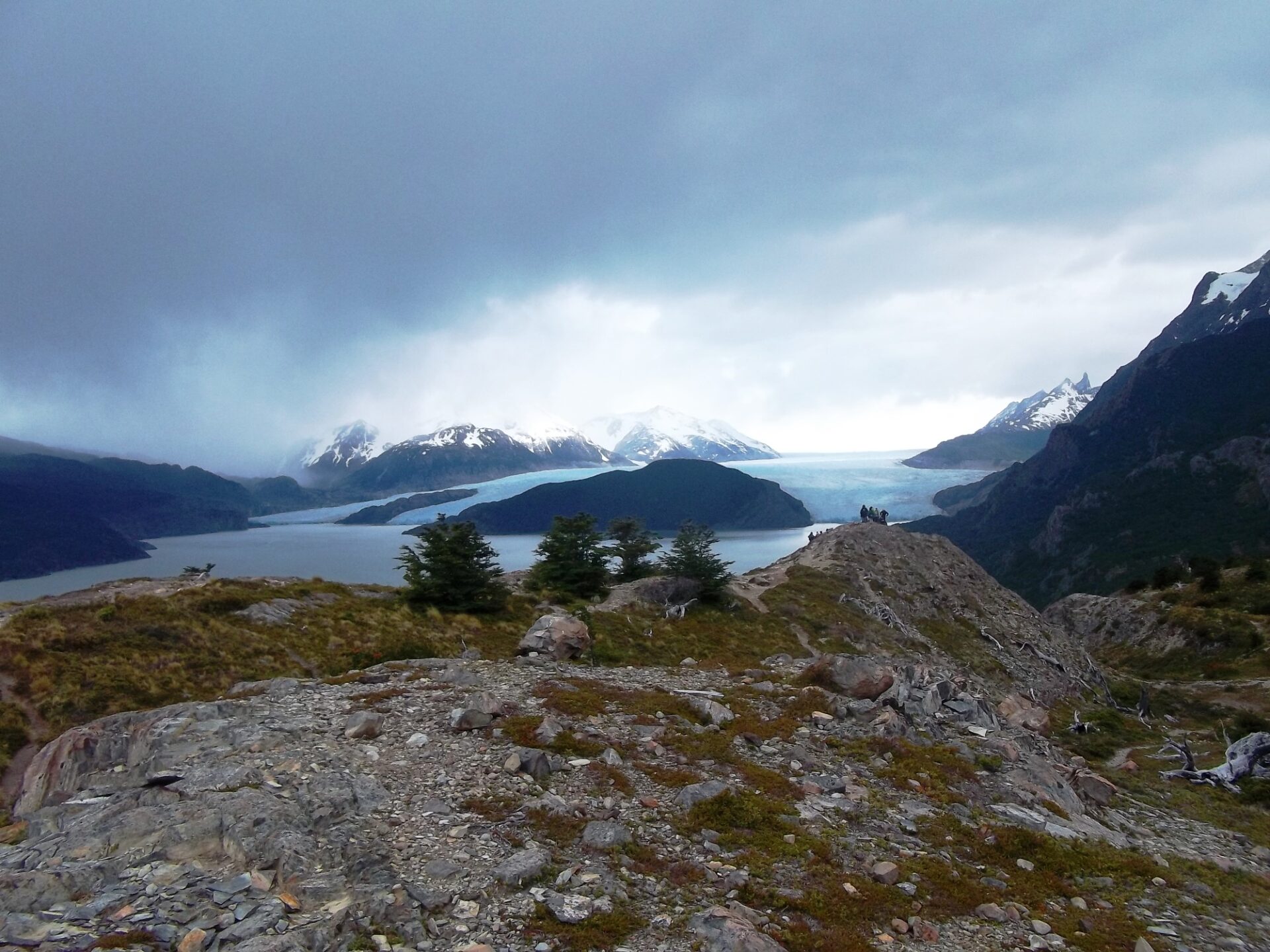
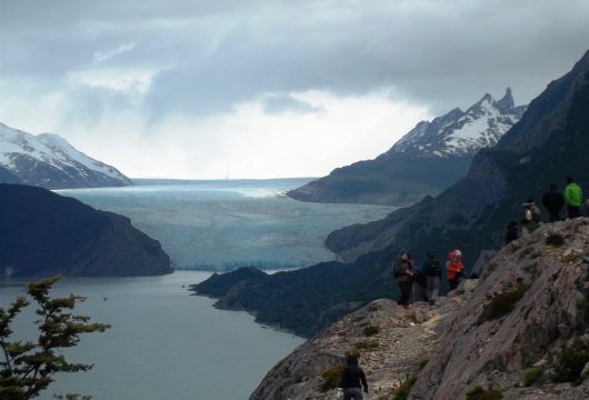
Day 4: Grey Glacier, Refugio Grey (B,L,D)
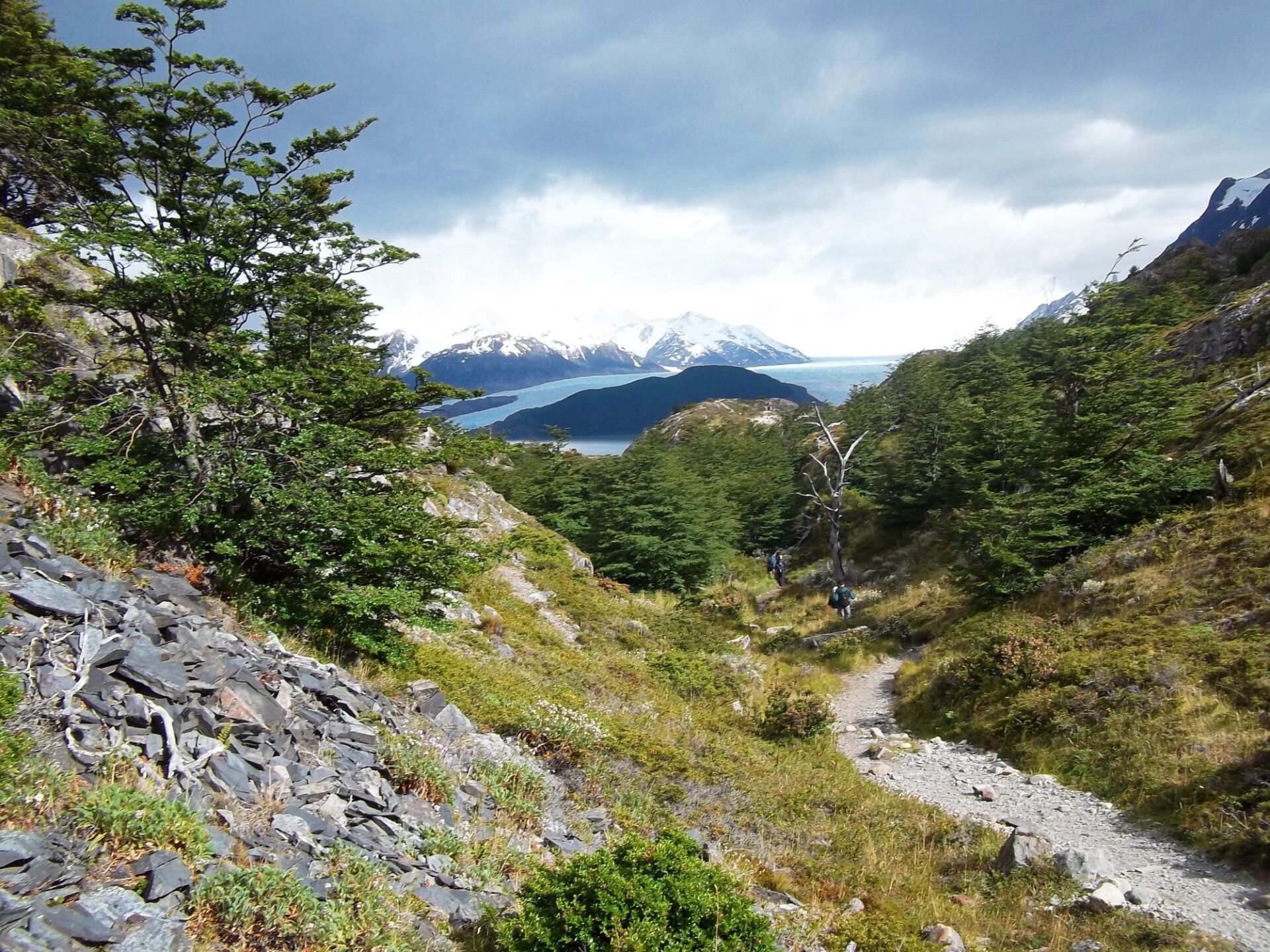
We’ll set out early, ascending 200m (656 ft.) on the winding path that takes us to Laguna Negra. Here, we’ll see sections of the massive Southern Patagonian Ice Field, a geological phenomenon that still guards many unexplored peaks.
You’ll continue to Grey Glacier’s lookout point, passing forests and rivers, with possible sightings of the spectacled and flightless steamer ducks that live here.
We’ll have lunch at the lookout with the mammoth Grey Glacier at our feet and might be lucky enough to catch sight of ice calving from its huge walls into the freezing waters.
Kayaking: Today, there is the option to go on 2.5 hour kayaking excursion (advance booking required).
Hiking: 4 hours, 11 km / 6.8 miles
Highest altitude: 495m/1,624ft
Difficulty: Easy/medium
Accommodation: Camping or Refugio Grey
Meals included: Breakfast, boxed lunch, dinner
Day 5: Optional tours, return to Puerto Natales, ends (B,L)
Today starts easy with a free morning to stretch, relax and enjoy this amazing glacial landscape. You also have the option to go kayaking or ice hike on Grey Glacier (advance booking required).
After lunch we’ll set off by boat across Grey Lake, to the massive facade of Grey Glacier. We’ll stay for a while to observe the ice wall’s textures, lines and amazing colours – and of course, watch for ice calving.
On your return across the lake you’ll see the wind-sculpted “ice mushrooms” atop the massive peaks of Paine Grande, as we sail past blue-hued icebergs.
On dry land once again, we’ll hike 20 minutes along Grey Beach to meet our transfer which takes us back to Puerto Natales where we end our journey.
Activities: 2-hour boat trip, 20 minute hike
Difficulty: Easy (ice hike: medium)
Accommodation: None. We can book hotels in Puerto Natales on request.
Meals included: Breakfast, boxed lunch
Prices From $2,700 / £2,195 per person
What's Included?
Meals from dinner on day 1 to boxed lunch on day 5, sleeping bag, catamaran crossing of Lake Pehoé, park entry ticket, bus to and from Puerto Natales and Torres del Paine National Park, use of shared bathrooms with hot showers, toilets, and personal locker, English-speaking guide
Note: You will carry your own belongings in your backpack; we suggest a maximum weight of 15kg.
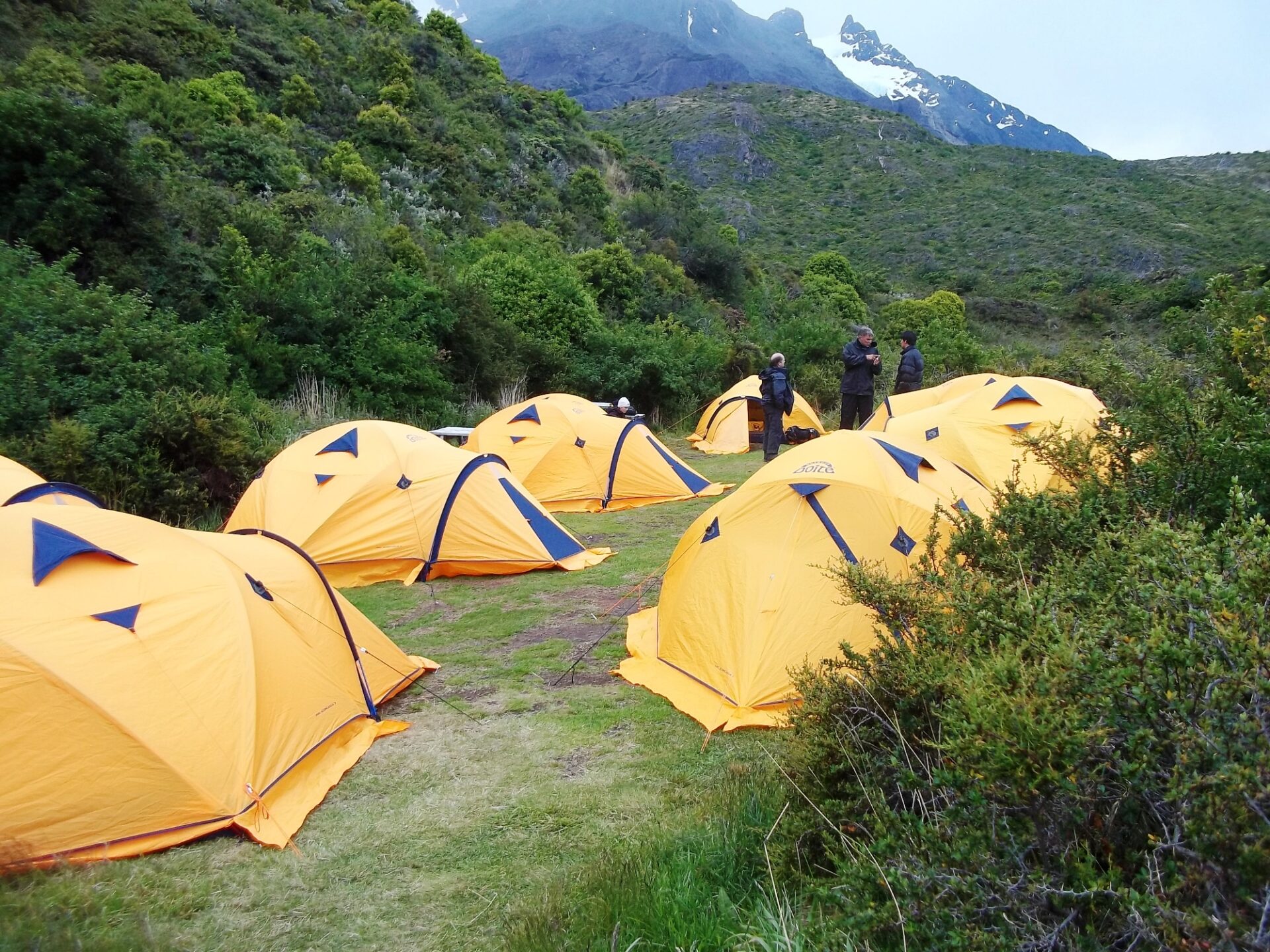
CAMPERS: Pre-set-up mountain quality tent, sleeping bag and sleeping mat.
HOSTELS: Comfortable bed in a shared room (6 beds).
HOTEL LAS TORRES: Private room (2 nights) then shared accommodation.
What's Not Included?
International and domestic flights, insurance, personal items, snacks, alcoholic or soft drinks, and a sleeping bag liner and towel.
Accommodation
Choose between camping, mountain hostels (refugios), and two nights at Hotel Las Torres. The guided trip also offers optional upgrades (subject to availability) throughout.
Campers and hostellers have access to the same shared facilities.
- CAMPERS: Pre-set-up mountain quality tent, sleeping bag and sleeping mat.
- HOSTELS: Comfortable bed in a shared room (6 beds).
- HOTEL LAS TORRES: Private room (2 nights) then shared accommodation.
Camping: The tents arranged for this program are typical mountain tents that are set up ready for your arrival and come with a sleeping bag and mattress.
Hostels: Mountain hostels, called refugios, have bunk beds in rooms that are shared with up to six other travellers.
Facilities at campsites and mountain hostels (refugios)
Shared bathrooms with toilets and hot showers, shampoo, soap, WiFi, shop/kiosk, restaurant and bar.
Tour Staff
For the guided trip, we employ local, English-speaking hiking guides to lead you through Torres del Paine National Park. They will explain the flora, fauna, and history of the area with you.
You carry your own belongings in your backpack – we suggest a maximum of 15kg.
Meals
We can cater for almost all dietary requirements – please enquire for more information.
Campers and hostel guests eat breakfasts and dinners in a communal dining hall. Breakfasts usually feature a mix of hot drinks, cereals, fruits and toast with jams.
Hikers receive boxed lunches from the site where they stayed and may feature sandwiches, crackers, snacks, and energy bars (the exact menu depends on the lodge). Dinners vary, too, often featuring pasta or rice dishes.
We recommend trekkers can take extra snacks with them before the hike or purchase items at hostel kiosks.
Activity Level
This is a moderate to challenging Torres del Paine W trek with some long ascents and descents. The total distance covered is 47 miles / 75.5km over four trekking days.
This is the right trip for energetic people who like to be active and have a spirit of adventure and a positive attitude. To enjoy this trek, it is essential to be in shape before arriving.
It is not wise to regard this trek as a means of getting into shape or losing excess weight. Start a program of conditioning well before departure.
Practical Information
Introduction to Patagonia
For most people, Patagonia evokes a vast, windblown plateau, jagged mountains and the life of the gauchos.
The steppe that occupies much of southern South America is only one aspect of a magical region, jam-packed with amazing and contrasting landscapes.
Patagonia (latitudes 40°-55°, approximately) embraces a vast portion of southern Chile and Argentina, from the Rio Colorado in the north, to Tierra del Fuego in the south.
For convenience, we have divided the region into three zones: the Lakes District of northern Patagonian, central Patagonia and southern Patagonia.
Geography of Patagonia
Southern Patagonia (latitudes 49° to 55°), encompassing the southern Andes of Chile and Argentina plus Tierra del Fuego, has an altogether more vertical aspect than the rest of Patagonia.
As the continent tapers towards its southern point, the Andes take on new characteristics and offer some truly impressive panoramas.
Much of southern Patagonia is characterized by virgin landscapes where man’s hand has either not been present or, because of the scale of the landscapes, goes almost unnoticed. To the west of the semi-arid Patagonian plateau, mile-high granite spires – e.g. Cerro Torre and Fitzroy in Argentina and the Torres and Cuernos del Paine in Chile – rise abruptly from the Andean foothills, while vast blue glaciers, fringed by southern beech forest, gouge out thevalleys below.
At the heart of these magnificent landscapes lies the South Patagonian Ice Field, an utterly remote icy wilderness spanning hundreds of kilometers, whose glaciers – including the Perito Moreno and Upsala – are tens of kilometres long by severalkilometers wide.
Also characteristic of the southern Patagonian Andes are its turquoise, iceberg-filled lakes. To the west lies the southern portion of the Chilean Archipelago, comprising snow-capped islands and fjords.
Across the Magellan Straits from mainland Patagonia lies Tierra del Fuego which, like the rest of Patagonia, is divided between Argentina and Chile.
The north and east of Tierra del Fuego is flat, but flanking the Beagle Channel in the south, the tail end of the Andes provide very dramatic mountain scenery.
The Lake District (latitudes 40° to 45°) or the Araucania, is a region of dramatic conical volcanoes, evergreen, high-canopy forests and, of course, lakes.
It straddles the Chile-Argentine border, and also takes in Chiloe island, in the extreme north of the Chilean Archipelago. This region stretches from Temuco in the north to Chiloe in the south.
Central Patagonia (latitudes 45 to 49) is one of South America’s best-kept secrets. The vast wilderness area can be divided in two:
- The dry band of Andean foothills and wind-blown plateau lying on the Argentine side of the Andes. This remote area is traversed north to south by a gravel highway known as the Ruta Cuarenta (Highway 40).
- The Chilean portion to the west of the Andean watershed, often referred to as the Careterra Austral (after the little-used gravel highway that crosses it from north to south).
This huge region, embracing the sparsely-inhabited southern Araucaria and Aisén Region, features temperate rainforests, snow-peaks (often extinct volcanoes), lakes and, to the west, the Chilean Archipelago: a labyrinth of fjords and mountain-islands. This, the Chilean portion of central Patagonia, boasts the northernmost of Patagonia’s many giant, sea-level glaciers.
The San Raphael Glacier, probably this region’s most famous landmark, is an immense hanging glacier whose seracs calve into an iceberg-filled lagoon.
Find out more about Patagonia with our blog about its wildlife.
Vaccinations for Patagonia
We strongly suggest that everyone planning to travel to Patagonia visits their local doctor/travel clinic prior to departure for the latest vaccination information.
Recommended vaccinations
- Up-to-date diphtheria and polio.
- Tetanus or tetanus booster. (These three are effective for ten years.)
- ‘Havrix’ for Hepatitis A. The course of two injections protects you for ten years. Gamma globulin is cheaper butless effective.
- Typhoid vaccine is recommended by some doctors although it will not provide total protection and being careful about what you eat and drink is your best defence. It is given in two shots, four weeks apart and lasts for three years. Unless at exceptional risk, people over the age of 35 who have received four or more courses of typhoid immunisation need no more.
- A pre-exposure rabies vaccination is worth considering if you are going to be in contact with animals or morethan 24 hours away from a reliable source of vaccine. Hikers are at some risk from rural dogs, certain of which carry rabies, and those visiting coastal or rainforest areas could be exposed to rabid bats.
- Malaria is not a risk in Patagonia.
Kit list
Be nice to your feet! Make sure hiking boots are broken-in. Bring moleskin, Second Skin (or similar) for fast foot treatment and blister prevention.
If you are bringing a camera, include plenty of film or digital cards with enough megabytes for hundreds of pictures and spare batteries. Please note, film and digital cards are difficult to find and often expensive to buy in Patagonia.
When planning for the varied climatic conditions encountered in Paine, layering is the most practical and versatile clothing system. It’s worth remembering that our clothing keeps us warm by retaining and isolating the heat we ourselves create, and that you carry all your own kit around Paine.
We suggest you leave all other luggage in Puerto Natales hotel and just take the minimum. Stuff sacks are great for sorting your gear. Use different sizes and colours to differentiate the contents in your duffel bag/backpack.
Typically, you will need a spare set of clothes, a water-bottle, fleece or wind stopper jacket, rain jacket & trousers, your camera and wash kit. Keep it light.
Layering
To best maintain body heat, several layers of lightweight, warm and quick-drying clothing are far more efficient than one or two thick layers. Layers should have the following qualities:
- Breathability (able to wick away the humidity produced by sweat):
- Isolation (able to keep in the warm air our body produces); and
- Impermeability (able to impede the passing of wind and water).
First (base) layer: This layer wicks the sweat away from our skin, thus helping keep the body dry and warm. To this end, synthetic fabrics such as polypropylene should be used.
Mid layers: These isolating layers should also be synthetic (e.g. the known polar linings such as polartec or windblock, which are light and insulate twice as well as wool). Very important layers for retaining body heat.
Outer layer / shell: Finally, the vital layer which protects us from climatic adversities. A breathable, wind-proof and waterproof anorak, such as Goretex.
Suggested kit list
- Synthetic inner socks (e.g., polypropylene, thermastat, coolmax) and 2 pairs thick loop-stitch/wool socks for cold.
- Trekking boots – should be well broken-in, waterproof and provide good ankle support.
- Trainers/sandals for evenings & river crossings.
- Base layer leggings
- Goretex-type over-trousers
- Trekking trousers
- Shorts if you prefer, or zip off trousers
- Thermal base layer shirt
- Microfleece mid-layer shirt
- Shirt/t-shirts
- Fleece jacket or similar
- Warm jacket (down or synthetic)
- Waterproof Goretex-type jacket.
- Broad-brimmed sunhat, essential.
- Warm hat, fleece or wool. (N.B. Up to 30% of body heat can be lost through the head).
- Sunglasses with UV filter.
- Bandanna – to protect neck from strong sun and against cold if needed
- Gloves
- Daypack (approx. 30-50 litres). Comfortable and with waterproof lining or cover.
- Pair of telescopic trekking poles if you like using (can be rented)
- Water bottle (2 litres approx.)
- Personal first-aid kit to include: painkillers, plasters (band-aids), moleskin, anti-biotic cream, anti-diarrhoea tablets, throat lozenges, re-hydration salts & personal medication.
- Insect repellent.
- Towel & wash-kit.
- Wet Wipes/antiseptic hand-wash cream.
- Sunscreen (factor 30+) and lip salve.
- Head-lamp (plus spare bulb and batteries).
- Penknife.
- Plastic bags – ‘Zip-loc’ & tough bin liners.
- Camera and film / memory cards (take at least twice the amount you think you will need!).
- Book, e-book, mp3 player/iPod or other to help pass the time
- Binoculars.
Miscellaneous others
- Money belt.
- Passport.
- U.S. dollars cash, mixed-denomination notes, undamaged and unmarked, or local currency
- ATM cash/credit card.
- Personal & medical insurance certificates.
Quick facts about Patagonia
Chile
Official name: Republic of Chile
Country population: 17,000,000
Capital city: Santiago (6 million)
Largest cities: Santiago, Concepcion, Valparaiso
Languages: Spanish (official)
Official currency: Chilean Peso
Major industries: Copper mining, agriculture, fish
Time zone: GMT-5 in winter (Mar-Sep) and GMT-4 in summer (Sep-Mar)
Argentina
Official name: Argentine Republic Country
Population: 40,000,000
Capital city: Buenos Aires (11 million)
Largest cities: Buenos Aires, Cordoba, Rosario
Languages: Spanish (official)
Official currency: Argentine Peso
Major industries: Agriculture (Soy), motor vehicles, chemicals
Argentina: GMT-3
ATOL holiday protection
Andean Trails has 25 years of experience of putting together the best South America holidays.
We pay a fee to the CAA for every licensable passenger we book since we hold an Air Travel Organiser’s Licence granted by the Civil Aviation Authority. In the unlikely event of our insolvency, the CAA will ensure that you are not stranded abroad and will arrange to refund any money you have paid to us for an advance booking.
We also offer ATOL (Civil Aviation Authority) protected holidays to give our customers peace of mind when booking and travelling.
When you buy an ATOL protected air holiday package from Andean Trails Ltd you will receive a Confirmation Invoice from us confirming your arrangements and your protection under our Air Travel Organiser’s Licence number 6275.
You can read more about ATOL, who is covered and what protections you have if not ATOL-covered, on our ATOL page.
What is ATOL?
The CAA’s ATOL scheme offers protection to your money and your holiday if you book with us. Not everybody is covered (see ‘Who is covered?’ for more), as you must purchase an ‘air package holiday’ with Andean Trails to be protected.
And ‘air package holiday’ is defined as including a flight and some ground services (hotel, transfer, trek etc). This is also known as an ‘ATOL-protected holiday’.
Who is covered?
To be covered by ATOL, you must book a flight and some ground services with us and be from the UK. If you are from the UK and only book ground services and no flights, you are not covered by ATOL (see below for more on how non-ATOL clients are covered).
If you are outside the UK and buy flights with us, you will be ATOL protected IF any of the flights booked with Andean Trails touches/stops in the UK at any point during your holiday package booked with us.
If you buy your flights elsewhere, please check with that agent if you are ATOL protected. Be careful with online flight purchases and make sure you know what protection you have, if any, before paying for flights.
Not all holiday or travel services offered and sold by us will be protected by the ATOL scheme. Please ask us to confirm what protection may apply to your booking.
For land only holidays not involving any air travel, in accordance with “The Package Travel, Package Holidays and Package Tours Regulations 1992”, all UK passengers booking with Andean Trails Ltd. are fully protected for the initial deposit and subsequently the balance of all money paid to us, arising from cancellation or curtailment of travel arrangements due to the insolvency of Andean Trails.
I’m not ATOL covered, what protection do I have?
If you are not ATOL covered, any payments you make to us go to a Trust account.
We can only access this money once your tour has been completed, meaning that if anything happens to Andean Trails Limited while you are on holiday, then your money is secure and you can either complete the trip or be able to make it home.
If you pay for your holiday with a credit card, some offer payment protection – please check with your cardholder.
You also should have cancellation protection written into your insurance (which we recommend you have at the time of booking) in case you need to cancel.
Chilean Patagonia
Chilean Patagonia is a pristine wilderness of fjords, glaciers, plains, mountains and forests.
Southern Patagonia’s main attraction is the Torres del Paine National park. The granite spires attract many visitors to what some have called the 8th Wonder of the World. The park is a trekkers paradise with two classic treks, the Paine W and the Paine Circuit.
Northern Patagonia, the Aysen region, is one of the least populated parts of the country and is blessed with spectacular countryside.
The main airport is Balmaceda near the city of Coyhaique and must see places include Lake General Carrera and the Marble Caves, The San Rafael Glacier, the Quelat Hanging Glacier as well as driving the Austral Road.
The Futaleufu River is a must for white water enthusiasts.
The region also offers great horseback opportunities as well as kayaking ones. Nature enthusiasts can admire the impressive scenery, imposing glaciers and fascinating wildlife and flora.
Puerto Natales, Chile
Puerto Natales has the feel of a small frontier town.
Located on the banks of the Last Hope Sound this town had its origins in the shipping out of lamb from the local estancias.
Now it is the gateway to the Torres del Paine National Park and boasts an impressive selection of accommodation and restaurants.
Nearby attractions include the Milodon Cave and a full day sailing tour to the Balmaceda and Serrano Glaciers.
If you have time it’s worth trekking to the top of the nearby Dorotea hill for a spectacular view of the surrounding country side.
Torres del Paine National Park, Chile
The granite spires of Chile’s Torres del Paine National Park are one of the great draws to Patagonia.
The Horns of Paine and the Towers of Paine look down on a network of valleys and lakes punctured by the odd glacier, which are a trekker’s paradise.
There are two classic treks, the Paine W and the more challenging Paine Circuit.
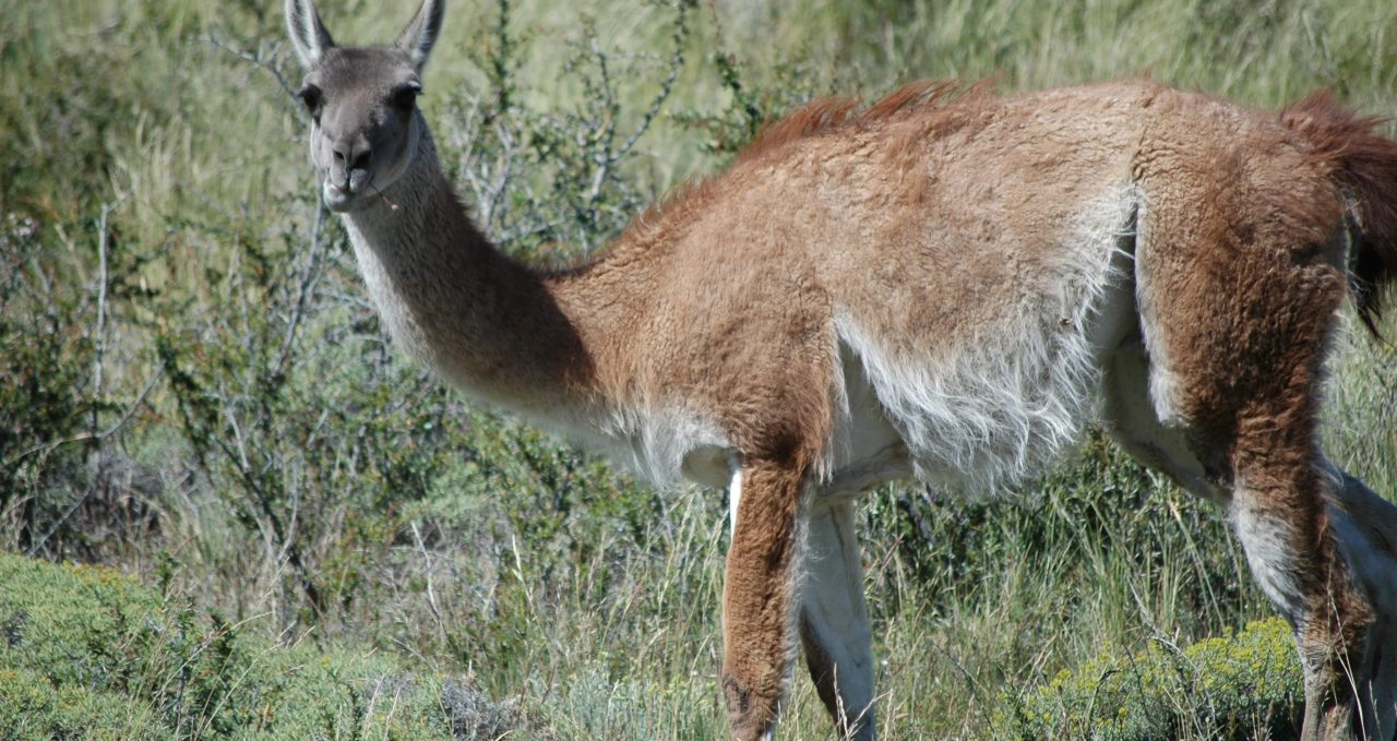
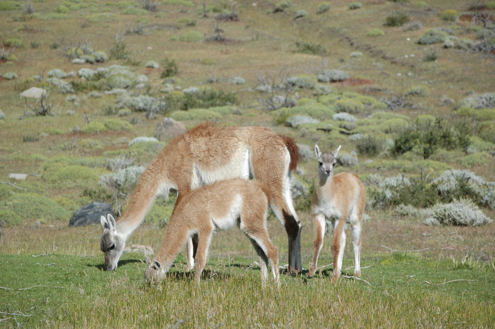
As well as the spectacular scenery the flora and fauna are great attractions and you will find many herds of guanacos as well as rheas, the odd Pudu – a rare miniature deer.
And if you are lucky, even a puma.
Prices From $2,700 / £2,195 per person
2026-27 prices.
Groups form with 2 people
Camping (sharing a tent): $2,700pp
Single supplement $400pp
Refugios (shared room, 6-8 people): $2,900pp
Single rooms not available.
+ a porter to carry 15kg days 2-4, $800 in total.
Lake Grey kayak: +$250pp
Grey Glacier hike: +$350pp


Dates & Prices
Prices From $2,700 / £2,195 per person
2026-27 prices.
Groups form with 2 people
Camping (sharing a tent): $2,700pp
Single supplement $400pp
Refugios (shared room, 6-8 people): $2,900pp
Single rooms not available.
+ a porter to carry 15kg days 2-4, $800 in total.
Lake Grey kayak: +$250pp
Grey Glacier hike: +$350pp
Can’t find what you’re looking for? Get in Touch
+44 (0)131 378 5593
+44 (0)131 554 6025
Suggested Trips
7-day Paine W Trek: EcoCamp Patagonia
https://www.andeantrails.co.uk/tour/paine-w-7-day-classic-trek/ a Group Tour
  a Tailor Made Tour
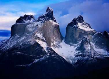
Prices From $2,037 / £1,656 per person
Dates: From January 2026 to April 2027
Duration: 7
Capacity: 12 people
More on trekking the Paine W trek, Patagonia As well as the beautiful highlights of Grey Glacier, French Valley and Towers and Horns of Paine – there is a bonus visit to the Milodon Cave and the Eastern lakes of Torres del Paine national park. In the award-winning EcoCamp, you…Express Paine W Trek: EcoCamp Patagonia
https://www.andeantrails.co.uk/tour/short-paine-w-highlights-trek/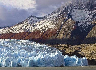
Prices From $1,481 / £1,204 per person
Dates: From January 2026 to April 2027
Duration: 5
Capacity: 16 people
More on Express Paine W Trek at EcoCamp Patagonia There are two long days of hiking that sandwich a more relaxed half-day of walking, to allow you to see everything. We spend a full day exploring the French Valley on foot. This is followed by a relaxing half day of…Hotel Las Torres, Paine, Chile
https://www.andeantrails.co.uk/tour/hotel-las-torres-torres-del-paine-chile/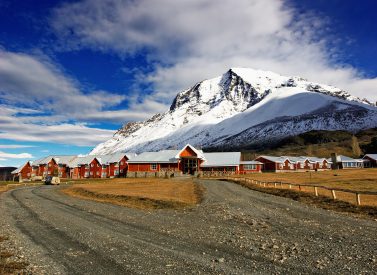

Prices From $3,210 / £2,610 per person
Dates: From January 2026 to April 2027
Duration: 4
Capacity: 16 people
More on Hotel Las Torres, Paine, Chile Start your journey in Punta Arenas or El Calafate from where you will be picked up and transferred to the hotel in the Torres del Paine. All your meals, open bar and daily excursions, walking, horse-riding, wildlife watching, boat trips, are included. There…Paine O Circuit Full Trek: Guided
https://www.andeantrails.co.uk/tour/paine-circuit-classic-trek/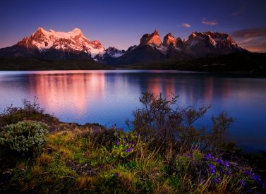
Prices From $3,791 / £3,082 per person
Dates: From November 2025 to March 2027
Duration: 9
Capacity: 12 people
More on trekking the Torres del Paine Circuit trek The Paine Circuit is rightly regarded as one of the world’s classic trekking routes. The Paine Circuit trekking route encompasses Paine and Dickson Lakes, Los Cuernos and the Torres of Paine, as well as Grey Glacier, seen from the pass. We…