Self-Guided Paine W Trek, Torres Del Paine National Park
![]() by Tom Shearman on 19th May, 2023
by Tom Shearman on 19th May, 2023
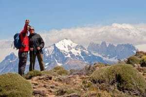
Chile’s Paine W is on many trekkers’ lists.
Patagonia is a trekker’s paradise, Kat headed off on a self-guided hike along the famous Paine W trek to find out where its appeal lies.
She came back with everything you’ll need to know about hiking the Paine W.
Getting to Torres del Paine National Park
To reach Torres del Paine National Park, you must first make your way to Puerto Natales in Chile’s Magellanic region.
You may fly to Puerto Natales during the high season (Nov-Mar). However, most people fly from Santiago to Punta Arenas, a Patagonia city three hours south of Puerto Natales. A comfortable bus (3-4 hours) connects Punta Arenas and Puerto Natales.
You can also travel overland to Puerto Natales from Argentina, taking a bus from El Calafate (5-6 hours) or Ushuaia (14 hours).
Paine W Self-guided Trek Briefing
The afternoon before the self-guided trek, a briefing will be held where you will be given a welcome kit consisting of:
- Map
- Bus ticket to the park
- Park entrance ticket
- Sleeping bag liner
- Light and quick-drying towel
- Water bottle
- Ticket for the catamaran ride out on your last day or into the park on day one if you end up trekking in reverse.
Most importantly, you will be talked through the logistics of the trek, the refuges, and the individual day hikes — where you can stop and drop your bag for a portion of the walk where you can refill your water bottles. You can ask any questions during the briefing.

Day 1: Arriving at Torres del Paine National Park
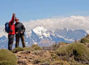
On your first day of the Paine W, you will set off around lunchtime on a comfortable bus to Laguna Amarga, one of the entrances to the park. The journey will take around three hours. As you get closer to the park, you will be treated to scenic views of the Paine Massif, the famous Towers, and plenty of guanaco.
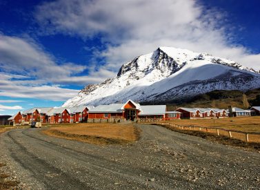
On arrival, you check into your accommodation; most will sleep at the Refugio Paine Central, the refuge (either in a shared dorm or a tent). There are options to upgrade to more glamorous lodgings such as the guided Ecocamp Classic Paine W Trek or Hotel Las Torres.
It’s worth taking a first little wander today. A small trail starts just outside Hotel Las Torres with some explanations about flora and fauna, plus beautiful views.
The refuge is extensive, with a spacious common area, oversized windows and a well-stocked bar. Time to get to know your fellow trekkers over dinner!
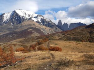
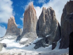
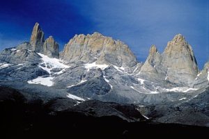
Day 2: Trek to the Base of the Towers
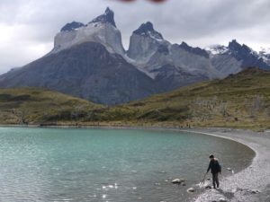
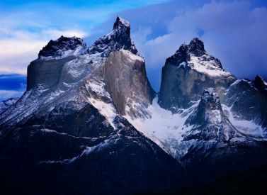
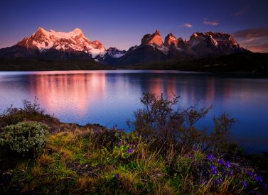
For many, the most iconic mountains of the Paine W trek are the granite towners or “Torres”, which rise triumphantly over Laguna Azul. To get to the lookout at the base of the Tower from Paine Central, it’s 10km each way, returning along the same route. You will hike with only your day pack.
Giving your legs a chance to warm up, the first part of the hike is gentle before slowly starting to climb, with Almirante Nieto Mountain looming to your left. As you take breaks and turn around, you are treated to beautiful views of isolated Patagonian highlands. Soon you reach Lenga Forest, the ancient Magellanic beech (Nothofagus Pumilio). Keep your eyes peeled for typical Patagonian birdlife; you may spot a Magellanic woodpecker.
It is a steady climb from here on, primarily through a forest on well-trodden paths. You reach Refugio Chileno by traversing a hanging bridge over the Paine Grande River. Refugio Chileno is an alternative accommodation for the first night or a pleasant spot to break the walk and treat yourself to a coffee. You can use the bathrooms here and refill your water.
After a pause at Chileno, you will trek alongside the river as it comes tumbling down the mountains. The path becomes a little more scrambly until you reach the park wardens’ base. Another toilet opportunity, and then it’s for the final scramble to the Towers.

The last half an hour is more arduous going; a steep uphill, on rocks and partly through a small stream. You leave the forest behind and walk on boulders until you reach your destination. The Towers rise in all their glory in front of you in this most serene location.
After a well-deserved break and plenty of photos, return the same way, completing your first walk of the trek and possibly the most challenging day. Dinner will be welcome tonight.
Distance: 12.5 miles/20km
Elevation: 1,100m/3,609ft
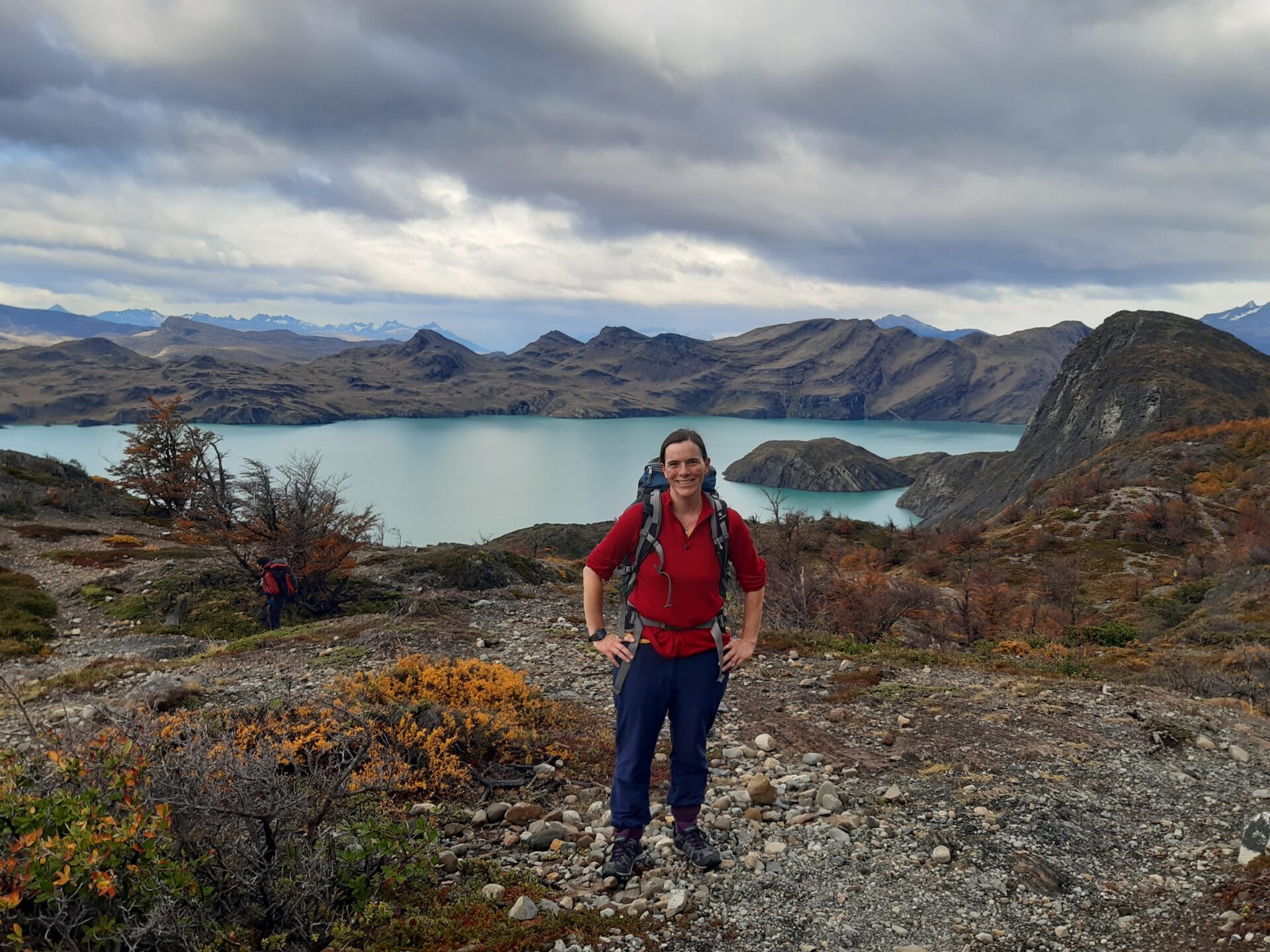
Day 3: Paine Central to Refugio Frances
Note: Alternatively, hike to Refugio Cuernos or Campsite Italiano.
After our steep climb yesterday, today is a little less taxing as you meander alongside Nordenskjold Lake, named after a famous Swedish explorer. You start along the same path as yesterday, but instead of turning to your right to head to the Towers, continue straight along a well-marked trail. It’s grassland all around as you slowly climb towards the hilltop in front of you.
There’s a hidden top, so it is only as you come up to the highest point that you are treated to a beautiful view that comes almost as a surprise. Below you lies the lake, and the chain of snow-covered mountains creates a stunning backdrop in the distance. Intoxicated by the view, you will forget the uphill quickly.
The next stretch has some climbs, but these are gentle and large stretches of the path without much ascent, always offering a view of Lake Nordenskjold as you dip in and out of woodlands and small bushes.
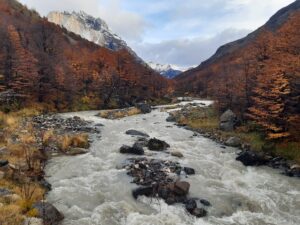
To keep you on your toes, be prepared for some river crossings today, hopping from rock to rock in the absence of bridges. You will likely find yourself walking in small streams for parts of the way, which overtake the path.
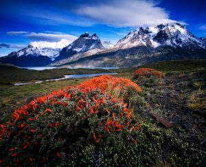
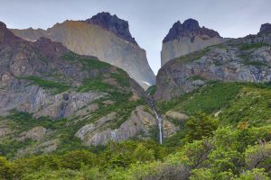
For the last stretch, you will be trekking with the mighty horns of Paine to your right, the “Cuernos”.
Today is less strenuous than the first day, but you are carrying a full backpack today, so you might find it a challenge for that reason alone.
Stay at Refugio Frances tonight to be a step closer to the French Valley than you would be if you stayed at Refugio Cuernos (which comes before Frances), but either is possible, logistically. Those that camp may want to continue to Campsite Italiano, which lies only half an hour from Frances, at the start of the French Valley.
All three refuges are small, and in high season, you may find yourself taking turns for dinner. Pick the last dinner slot if you hope to linger a little in the communal area.
Distance: 8 miles/13km
Elevation: 400m/1,312ft
Day 4: Trekking the French Valley
One of the most beautiful days of the Paine W, today the French Valley awaits. Once you arrive at Campsite Italiano from your refuge, you can leave most of your belongings here and continue with a day pack only. You will be grateful for the weight reduction you are carrying up the valley, as it is a steady uphill from the word go. The weather can be unreliable here, but if the weather gods are on your side, make sure you trek to the highest viewpoint!
Lenga forests are all around you as you steadily hike to the first lookout, aptly named the French viewpoint, Mirador Frances. For the entire way, there are views of the French Glacier to keep you going. However, the views from Mirador Frances are just spectacular. Linger long enough, and you may hear a bang, followed by a small avalanche launching snow down the French Glacier.
Don’t tarry too long as you still have some way to go to Mirador Britianico, the British viewpoint. While you are still climbing steadily, it feels like the most challenging part has passed. Enjoy the woodlands as you continue before finally emerging into a barren stretch.
The final 45 minutes require traversing rocky patches with a final push to the lookout. Before you, the mountain range opens up and gives a 180 panorama, with the valley behind you. Cerro Cota and Cerro Catedral rise before you. It’s worth keeping going for this view.
Return the same way, and yes, unfortunately, you must pick your bag up again at Italiano.
Getting to Paine Grande Refugio is still 4.5 miles/7.5 km, but don’t despair. This stretch of the way is easygoing and picturesque, a respite from the climb.
Your arrival at Paine Grande will be a welcome end to your day. The refuge is located on Lake Pehoe. This refuge is extensive and has a small minimarket should you need to stock up on snacks.
Distance: 13 miles/21 km
Elevation: 800m/2,625ft
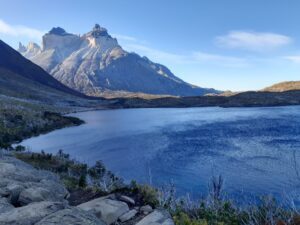
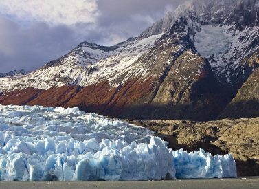
Day 5: Grey Glacier and Return to Puerto Natales
A final push today, so get those weary legs going! The missing stretch of the Paine W takes you up into Grey Valley, intending to get as good a view of Grey Glacier as possible.
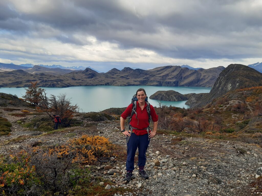
The first part of the walk is pretty uneventful, so do turn around occasionally to catch a view of the lake and the surrounding mountains to get the motivation to carry on. After about an hour, however, you come up over the hill and are rewarded by seeing the pretty Los Patos lagoon.
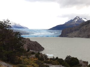
Shortly after comes the view you’ve sought; Lago Grey and the glacier at its far end. Keep moving as the views will only improve, and once you reach the first viewpoint, you will have a beautiful panorama. For many, this may be the end of their W as they retrace their steps.
If you can, and if time allows, carry on to the second viewpoint. Temporarily the views are replaced by woodlands, and you are beginning to wonder if this best view exists. Forge onwards – it’s worth it.
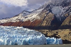
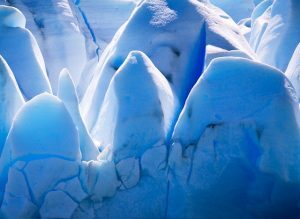
After about three hours, you will see Refugio Grey emerge between the trees. Power on past the refuge, following the signs to the glacier viewpoint. A mere 10 minutes later, the glacier comes into view as you leave the woods behind. You are now close enough to see the broken-off bits of glacier ice below you, sparkling white and ice blue, with the glacier as a perfect backdrop.
You have reached the end of your W. Take a triumphant photo in front of Glacier Grey to prove your hard work.
Watch your time for your return, as you need to make your way back in time to get the catamaran this evening.
There is likely still time to rest your legs at Refugio Grande before the 20-minute catamaran ride takes you to Pudeto on the other side of Lake Pehoe. Here the bus waits to return you to civilisation, back to Puerto Natales.
Distance: 15 miles/24km
Elevation: 836m/2,743ft
Self-Guided Paine W Trek: Know Before You Go
You will be well catered for as your trek includes all meals. Breakfast, box lunch and dinner, and – dare we say it – even a welcome drink at the refuges. Box lunch is substantial with a large sandwich, a piece of fruit, a healthy snack such as nuts and dried berries, and a snack bar or a chocolate bar. You can bring additional snacks, but most will find the box lunch sufficient.
At all refuges, you can buy extra snacks and drinks.
Paying by card is easy everywhere in the park, including at the refuges.
Bring a padlock for staying at the refuge to lock your belongings in the lockers provided in the dorms.
All refuges have electricity to charge your phone/camera.
Bring a torch, a first aid kit and earplugs if you are a sensitive sleeper.
Refuges are well equipped, clean, provide hot water, and are comfortable. Tents are put up for you and come fully equipped with mats and a suitable sleeping bag for low temperatures.
Bring sunscreen! Even if the days aren’t hot, the ozone layer here is thin, and you will burn quickly.
Insect repellent in summer is necessary to keep the beasties at bay.
Self-Guided Paine W Trek: Best Time to Travel
October to March are high season months in this part of the world. You must book in advance as refuges fill up quickly. The weather can be hot in January and February. However, the summer season also brings high winds, so be prepared for the elements. Rain is not unusual at this time of year.
The park will be wonderfully green, and you will experience long days of sunshine, with plenty of socialising at the refuges!
September and April are shoulder months and often dismissed as a good time to go, but they can surprise you. September is springtime, and flowers are starting to come out, adding colour to the park. It can still be chilly, and you may see some snow.
April is autumnal, and the trees’ colours, in orange, brown, red and yellow hues, are simply stunning. The weather can be unpredictable and early snow is possible, but equally, you may be catching only autumnal sunshine.
Neither September nor April typically experiences high winds, and FAR fewer trekkers are around. Check the weather forecast to get an idea of conditions.
Wintertime, between May and August, is a tricky time to visit but with a guide, possible. Prepare for snow and short days as well as some refuges closing. Logistically, day hikes may be better at this time of the year.
Been inspired? Contact us for more.
Share
Suggested Trips
7-day Paine W Trek: EcoCamp Patagonia
 a Group Tour
 What's a group trip?
Join a small group of like-minded travellers on a guided trip.
 a Tailor Made Tour
 What's a tailor made trip?
We put together a bespoke tour to fit your requirements.


Prices From $2,037 / £1,656 per person
Dates: From January 2026 to April 2027
Duration: 7
Capacity: 12 people
More on trekking the Paine W trek, Patagonia As well as the beautiful highlights of Grey Glacier, French Valley and Towers and Horns of Paine – there is a bonus visit to the Milodon Cave and the Eastern lakes of Torres del Paine national park. In the award-winning EcoCamp, you…Express Paine W Trek: EcoCamp Patagonia
a Group Tour What's a group trip?
Join a small group of like-minded travellers on a guided trip.
a Tailor Made Tour What's a tailor made trip?
We put together a bespoke tour to fit your requirements.
Prices From $1,481 / £1,204 per person
Dates: From January 2026 to April 2027
Duration: 5
Capacity: 16 people
More on Express Paine W Trek at EcoCamp Patagonia There are two long days of hiking that sandwich a more relaxed half-day of walking, to allow you to see everything. We spend a full day exploring the French Valley on foot. This is followed by a relaxing half day of…Guided Torres del Paine W
a Group Tour What's a group trip?
Join a small group of like-minded travellers on a guided trip.
a Tailor Made Tour What's a tailor made trip?
We put together a bespoke tour to fit your requirements.
Prices From $2,700 / £2,195 per person
Duration: 5
Capacity: 16 people
More on trekking the guided Torres del Paine W trek, Patagonia Walk to the famous granite towers that give the park its name — Torres del Paine — with fantastic views of hanging glaciers, green lakes, and mountains. The name Paine comes from a Tehuelche Indian word meaning blue. The…Hotel Las Torres, Paine, Chile
a Group Tour What's a group trip?
Join a small group of like-minded travellers on a guided trip.
a Tailor Made Tour What's a tailor made trip?
We put together a bespoke tour to fit your requirements.

Prices From $3,210 / £2,610 per person
Dates: From January 2026 to April 2027
Duration: 4
Capacity: 16 people
More on Hotel Las Torres, Paine, Chile Start your journey in Punta Arenas or El Calafate from where you will be picked up and transferred to the hotel in the Torres del Paine. All your meals, open bar and daily excursions, walking, horse-riding, wildlife watching, boat trips, are included. There…Paine O Circuit Full Trek: Guided
a Group Tour What's a group trip?
Join a small group of like-minded travellers on a guided trip.
Prices From $3,791 / £3,082 per person
Dates: From November 2025 to March 2027
Duration: 9
Capacity: 12 people
More on trekking the Torres del Paine Circuit trek The Paine Circuit is rightly regarded as one of the world’s classic trekking routes. The Paine Circuit trekking route encompasses Paine and Dickson Lakes, Los Cuernos and the Torres of Paine, as well as Grey Glacier, seen from the pass. We…Paine W Winter Trek
a Group Tour What's a group trip?
Join a small group of like-minded travellers on a guided trip.
a Tailor Made Tour What's a tailor made trip?
We put together a bespoke tour to fit your requirements.
Prices From $2,430 / £1,976 per person
Duration: 6
Capacity: 16 people
More on Torres del Paine Trek in winter Trek Chile’s world famous Torres del Paine National Park in winter and you’ll be away from the crowds and closer to the wildlife. Trek up the French valley surrounded by spectacular granite spires and view the imposing Grey Glacier. In the park…